
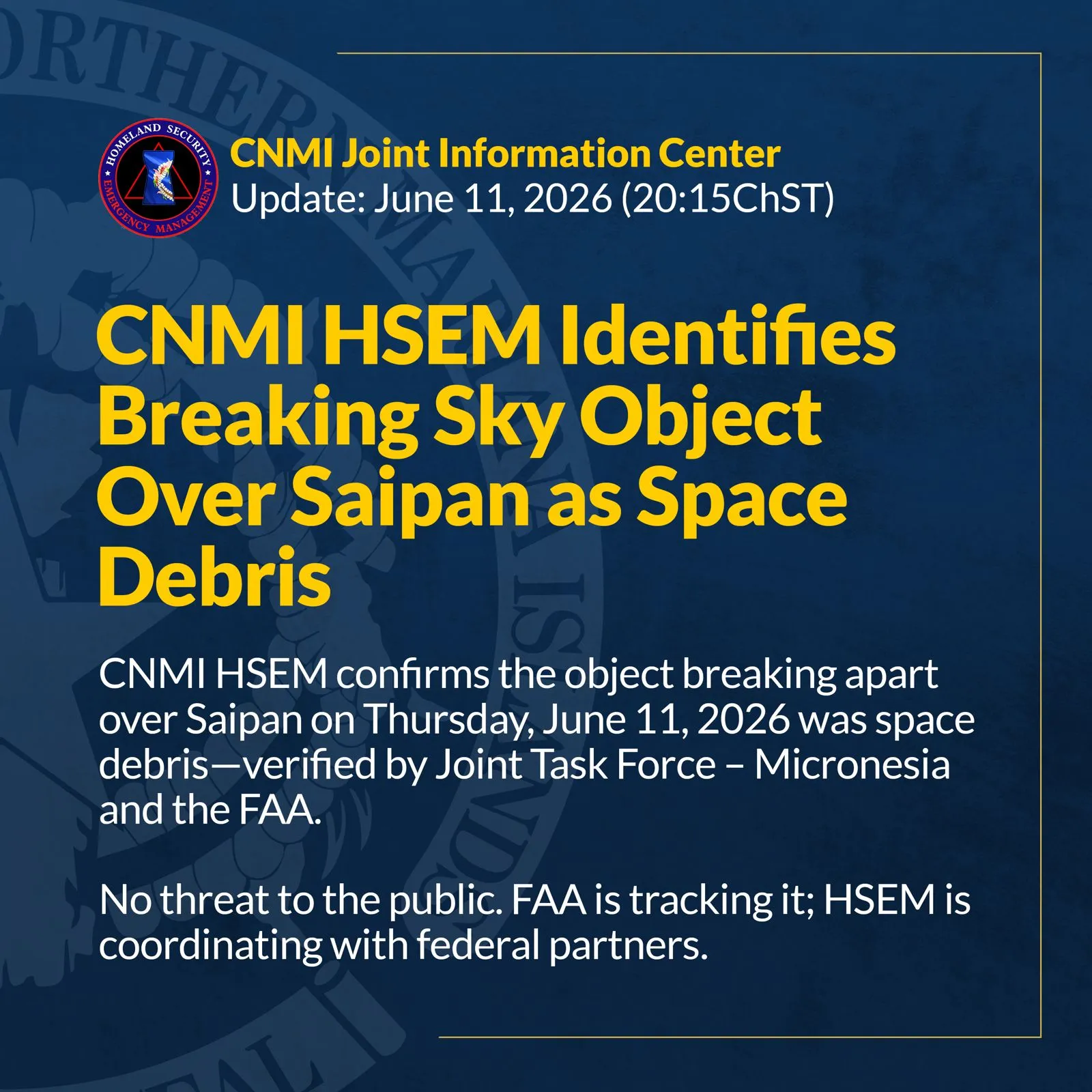


HAGÅTÑA (The Guam Daily Post) — The National Weather Service Guam Weather Forecast Office is monitoring a tropical disturbance west of Pohnpei.
Tropical Invest 94W was unorganized as of Saturday afternoon, but meteorologists expect it to begin organizing over the next 24 hours. It’s expected to bring increased winds and rain for Pohnpei and Chuuk this weekend.
It is in a favorable location for further development, as it tracks west-northwestward toward Guam, according to a Guam Homeland Security/Office of Civil Defense press release. Meteorologists can’t say for certain when the disturbance will organize into a storm and how close to Guam it will be at that point.
At the very least, 94W is expected to bring rain to the region Tuesday and Tuesday night with numerous to scattered showers and isolated thunderstorms. Scattered showers and thunderstorms are also possible Wednesday and Wednesday night.
The weather development follows the first Regional Climate conference, during which NWS provided a brief on short- and long-term weather predictions.
Guam, Rota, Tinian and Saipan may see four to six storms through December, with about half of the weather systems possibly being a typhoon when it is in the Marianas.
Landon Aydlett, warning coordination meteorologist for NWS Weather Forecast Office, Guam said the event was meant to share current trends in weather, climate and modeling.
Other Micronesian jurisdictions, like the Republic of the Marshall Islands, are forecast to have between zero and five cyclones, he said.
“Activity will vary significantly from east to west and north to south,” he said of the differing forecasts for islands. “We’re expecting it to be a busier tropical cyclone year for 2021 than what we had for 2020,” Aydlett reported.
With respect to Tropical Invest 94W, NWS and OHS/OCD officials said while there is still uncertainty, residents of Guam and the Northern Mariana Islands are encouraged is to take precautionary measures, including clearing yards of loose furniture or equipment, securing canopies and clearing trash, while the weather is clear.
Increased weather activity
Guam and the region have seen more typhoons in previous decades.
According to Mark Lander, an assistant professor of meteorology at the University of Guam who attended the conference, seven super typhoons “threaded between” the Marianas until Supertyphoon Paka hit Guam in 1997. A year prior, the Western Pacific experienced 43 numbered cyclones, 24 of which became typhoons. In 1992, five typhoons passed within 60 miles of the island. Guam saw three “eye passages” over land that year, according to Lander.
A transition to “neutral” weather conditions, and away from a La Niña pattern, which results in storms tending to develop well west of Micronesia, informed the forecast for the remainder of the year, according to Aydlett.
“We will see a little bit more activity across the region in the coming months. Our peak season for the Mariana Islands is typically August, September, October — and similar months for the rest of the region,” he said, later clarifying the forecast is “not a prediction of how many systems will make landfall” on any island.
Aydlett also highlighted the communication between weather experts and the community when storms and typhoons get closer to their islands.
Once watches or warnings are issued from the Joint Typhoon Warning Center, public advisories are released on a frequent, and regular basis.
Public advisories with general forecast information and broad changes to system development may be released up to eight times a day. Additional local statements, which provide localized information for individual islands are also scheduled. Once a cyclone’s center is within range of Guam-based radar (about 230 miles offshore), hourly updates will begin to be issued. The products are normally shared on social media pages for NWS Guam and Guam Homeland Security.
Aydlett told attendees that the conference was one of many ways the National Weather Service supports a “weather-ready nation.” Officials are now considering whether to schedule the regional report annually.

The National Weather Office-Weather Forecast Office facility in Tiyan, Guam tracks data day and night. On the left is a receiver that monitors balloon launches. The structure on the right is a polar sat receiver which constantly moves to communicate with satellites orbiting above.