


By Brandon Aydlett
NWS Meteorologist-in-Charge
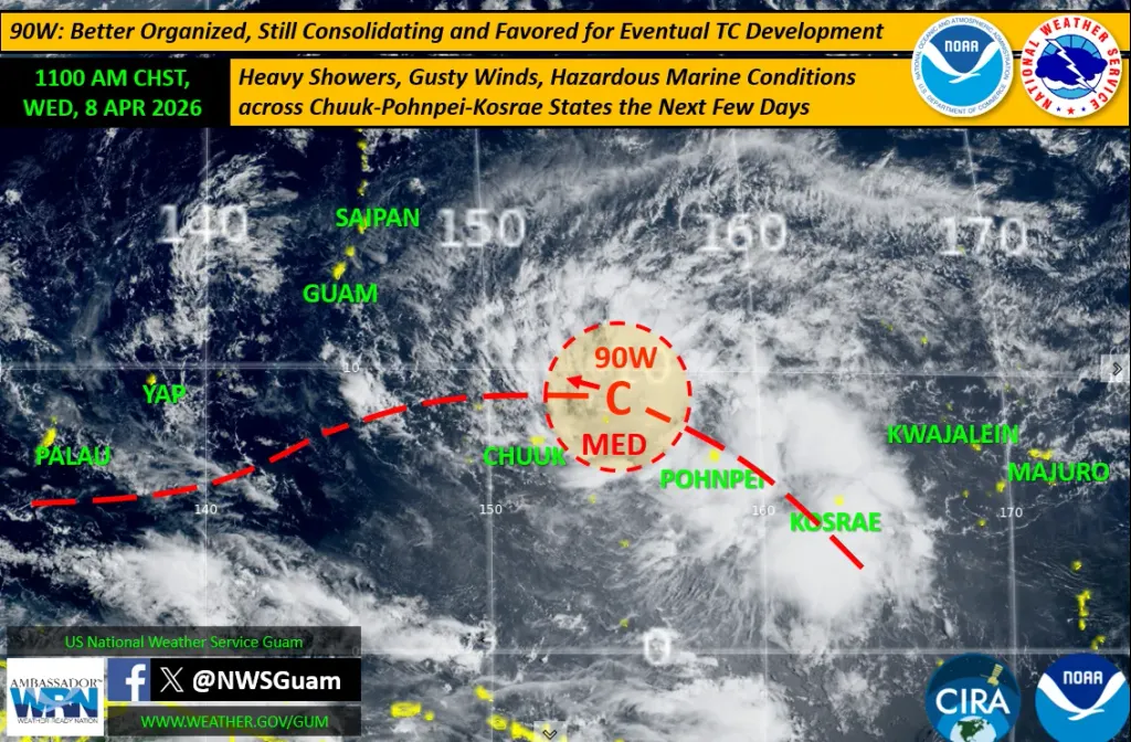
A TROPICAL disturbance, Invest Area 90W (east-northeast of Chuuk), remains under close watch as it slowly consolidates and becomes better organized. 90W’s development potential was just raised to a MED by the Joint Typhoon Warning Center, meaning that significant development into a tropical cyclone (tropical depression) is likely, but expected to occur beyond 24 hrs.
Morning visible satellite imagery shows a more-organized circulation that has drifted NW from Tuesday’s position south of Pohnpei. Though more organized, models continue to show a spread regarding potential intensity, exact route (west or northwest), bearing with respect to the Marianas (south of Guam, over Guam/CNMI or the far northern islands), and timing (late weekend or into early next week).
We expect that with its improved organization, we’ll see a narrowing of the ranges of these forecast aspects — perhaps within the next 12-24 hrs.
Though well away from 90W, peripheral conditions will still support widespread heavy rains, gusty winds and hazardous marine conditions across portions of Pohnpei and Kosrae States the next day or two. Similar conditions with NW-SW winds are anticipated across Chuuk State the next couple of days.
For the Marianas, a pleasant trade-wind pattern will persist through the work week, but as 90W closes in, conditions will deteriorate sometime over the weekend or early next week.
Even with a passage south of Guam, enhanced trade winds well to the north will become quite strong and gusty with increasing rains. Additionally, marine conditions will become increasingly hazardous over the weekend.