


By Walter Ulloa
For Variety
HAGÅTÑA (The Guam Daily Post) — The tropical disturbance that forecasters had their eyes on heading into Memorial Day weekend is now showing its hand, and for Guam, the news is better than it could have been.
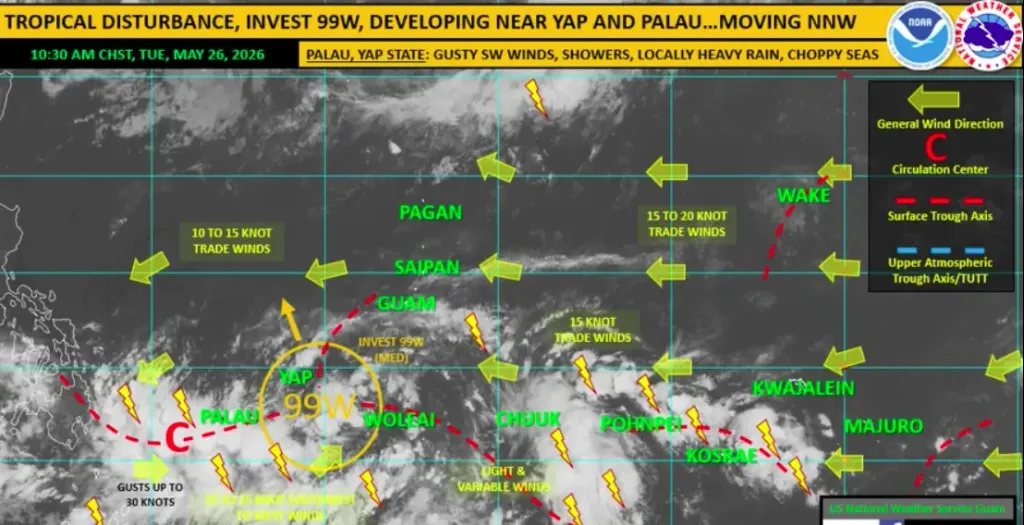
Invest 99W, which had been drifting slowly westward across Micronesia, was upgraded to medium for development by the Joint Typhoon Warning Center on Tuesday morning, putting it on track to become the region’s next tropical depression as early as Wednesday near Yap.
Its companion system, 90W, which had been churning south of Kwajalein, fizzled out. The JTWC closed it out a couple of days ago.
“It no longer exists,” Landon Aydlett, warning coordination meteorologist with the National Weather Service Weather Forecast Office Guam, told The Guam Daily Post. “However, 99W, the one closer to Chuuk and passing to our south, is showing steady development.”
99W does not pose a threat to Guam or the Commonwealth of the Northern Mariana Islands. The system is expected to lift north-northwest into the Philippine Sea, keeping well west of the Marianas as it develops, possibly significantly, in open waters.
“Fortunately, 99W does not pose a threat to Guam or the CNMI,” Aydlett said. “We’re going to stay on the far eastern periphery of the system.”
That eastern position, however, is not without its effects. The boundary between steady trade winds from the east and the outer circulation of 99W to the west will keep conditions unsettled across the island chain through midweek.
“We could see some spotty showers and trade winds surging across the area over the next couple of days,” Aydlett said. “We’re going to be on that eastern periphery, the convergence between the trade winds to our east and the peripheral winds around 99W to our west.”
Trade winds of 15 to 20 mph are expected to persist through mid- to late week. The NWS weekly outlook, also prepared by Aydlett on Tuesday, notes that combined seas of 3 to 5 feet will build to around 6 to 8 feet by week’s end as a long-period north swell and a southwest swell reach the Marianas.
As for the rest of the week and into the weekend, conditions are expected to gradually settle. Scattered showers will linger through Friday, with drier weather beginning to take shape by late weekend and into early next week.
“We’re looking at a fairly good weather outlook through the weekend, especially into early June,” Aydlett said. “As always, typical in the tropics, carry your sunglasses, but also keep a small umbrella handy.”
There are no watches, warnings or advisories in effect for the Mariana Islands. A special weather statement has been issued for western Micronesia, covering Yap and Palau, where 99W’s direct influence will be strongest, bringing gusty southwest-to-west winds, showers, heavy rainfall and choppy seas through the week.
For anyone planning travel toward Taipei or southwestern Japan over the coming week, Aydlett recommends keeping an eye on conditions as 99W continues to develop in the Philippine Sea.
No other areas of concern are on the radar.
“Right now, we don’t see any other suspect areas for possible development in the region,” he said. “We look like we’re going to be in pretty good shape once this disturbance develops and moves out of our way to the west.”
Later next week, on Thursday, June 4, Aydlett and colleagues will present the 2026 Western North Pacific Tropical Cyclone Season Outlook, updated El Niño information, and a recap of Super Typhoon Sinlaku.
For the latest forecasts and updates, visit weather.gov/gum or the NWS Guam Facebook page.