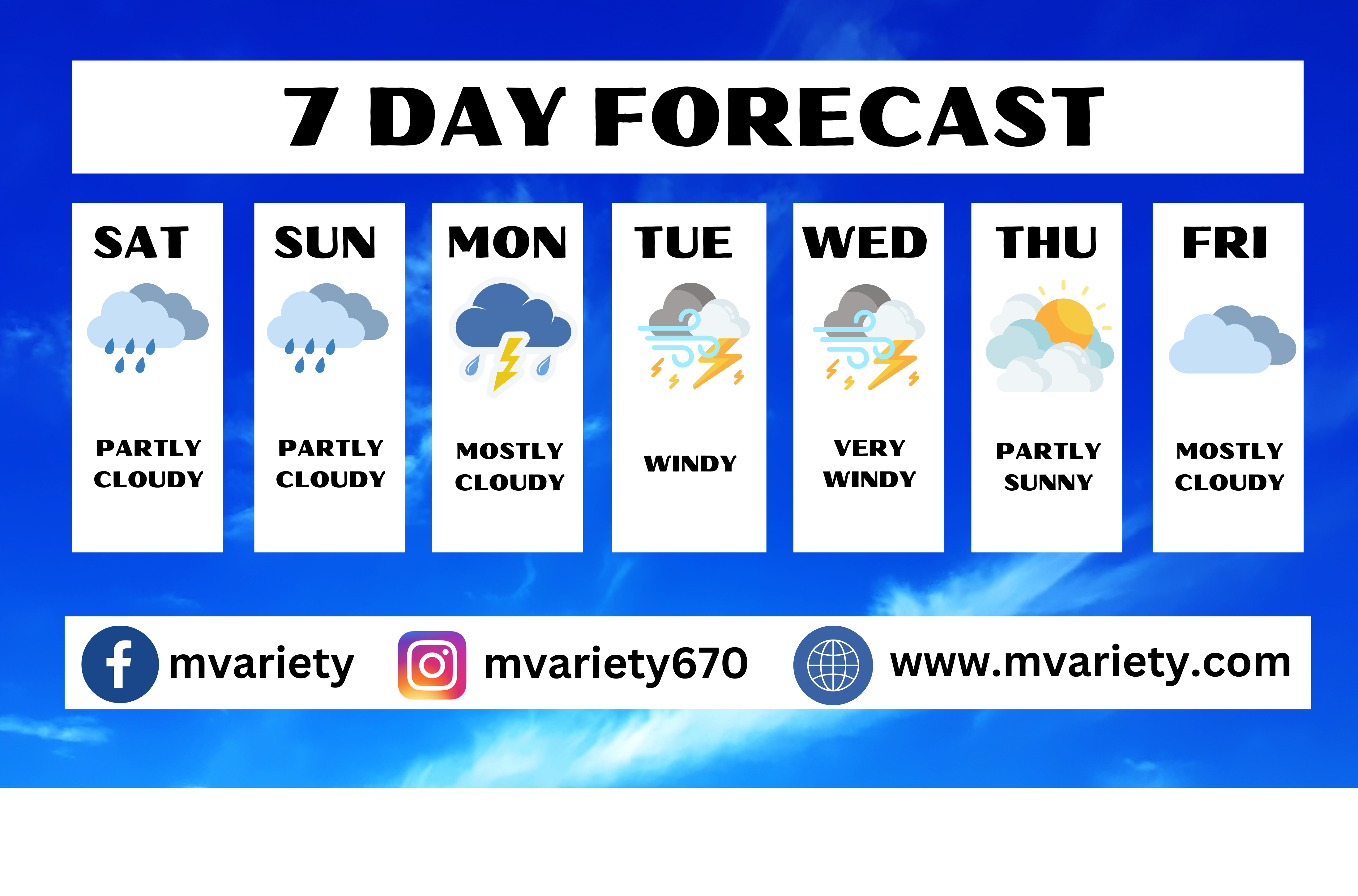


NWS — The National Weather Service in Tiyan, Guam has released the zone forecast for the Northern Marianas, including Saipan, Tinian, and Rota. The weather conditions for the region are expected to be partly cloudy with isolated showers throughout the weekend.
Today, residents can expect partly cloudy skies with isolated showers. East winds are predicted to blow at speeds of 10 to 15 mph, while temperatures will reach highs around 88 degrees Fahrenheit. The chance of showers is estimated to be around 20 percent.
As night falls, the weather will remain partly cloudy with isolated showers. Northeast winds will prevail at 10 to 15 mph, and temperatures will dip to around 80 degrees Fahrenheit. The chance of showers during the night stands at 20 percent.
On Sunday, the region will continue to experience partly cloudy skies with isolated showers. East winds are forecasted to blow at 10 to 15 mph, and temperatures will reach around 87 degrees Fahrenheit. The chance of showers is expected to be 20 percent.
Sunday night will bring mostly cloudy conditions with scattered showers. Northeast winds will blow at speeds of 10 to 15 mph, and temperatures will drop to around 80 degrees Fahrenheit. The chance of showers increases to 30 percent.
Looking ahead to Monday, the weather will be mostly cloudy with scattered showers and isolated thunderstorms. Northeast winds will pick up, ranging from 15 to 20 mph, and temperatures will reach highs of approximately 85 degrees Fahrenheit. The chance of showers is anticipated to be 40 percent.
As Monday night sets in, the weather will become breezy, with cloudy skies, numerous showers, and scattered thunderstorms. Lows will hover around 80 degrees Fahrenheit, and the chance of showers rises significantly to 70 percent.
Tuesday will bring windy conditions with cloudy skies, occasional showers, and a chance of thunderstorms. High temperatures will be in the mid-80s, and the chance of showers is expected to be around 80 percent.
The weather remains very windy on Tuesday night, with cloudy skies, occasional showers, and a chance of thunderstorms. Lows will be in the upper 70s, and the chance of showers will remain at 80 percent.
Wednesday will continue to be very windy, with cloudy skies and showers likely, along with a slight chance of thunderstorms. High temperatures will be in the mid-80s, and the chance of showers is forecasted to be 60 percent.
As Wednesday night arrives, the weather will be breezy, with mostly cloudy skies, a 50 percent chance of showers, and a slight chance of thunderstorms. Lows will be in the upper 70s.
Thursday will offer partly sunny conditions with a 20 percent chance of showers and thunderstorms. High temperatures will be in the mid-80s.
Thursday night and Friday will bring mostly cloudy skies, along with a chance of showers and a slight chance of thunderstorms. Lows will be in the upper 70s, while highs will reach the mid-80s. The chance of showers is estimated to be 40 percent.
For the coastal waters of the Mariana Islands, gentle to moderate trade winds and combined seas of 4 to 6 feet will persist throughout the weekend. However, conditions are expected to deteriorate starting on Monday as a developing circulation moves through or near the region, resulting in increased winds and seas. Small craft operators should be aware that hazardous marine conditions are likely by early Monday.
The marine forecast for today indicates an east wind blowing at 10 to 15 knots, with wind waves reaching 2 to 3 feet. The northeast swell is expected to be around 4 to 5 feet.
Tonight, a northeast wind at 10 to 15 knots is forecasted, accompanied by wind waves of 2 to 3 feet. The east swell will be around 4 to 5 feet.
On Sunday, the wind will continue to blow from the east at 10 to 15 knots, with wind waves reaching 2 to 3 feet. The east swell is anticipated to be around 4 to 5 feet.
Sunday night will bring a northeast wind at 10 to 15 knots, accompanied by wind waves of 2 to 3 feet. The east swell will be around 4 to 5 feet.
Monday’s conditions will see a significant increase in wind speeds, with a northeast wind of 30 knots and gusts up to 50 knots possible during stronger showers or thunderstorms. The wind waves will rise to 5 to 7 feet, while the southeast swell will reach 6 to 8 feet. Scattered showers and isolated thunderstorms are expected.
Tuesday will maintain the strong northeast wind, reaching up to 30 knots, with gusts up to 50 knots possible during stronger showers or thunderstorms. Combined seas are predicted to be 10 to 13 feet, and occasional showers along with a chance of thunderstorms can be expected.
Wednesday will experience a shift in wind direction, with a southwest wind at 30 knots and gusts up to 50 knots possible during stronger showers or thunderstorms. Wind waves will range from 4 to 7 feet, and a southwest swell of 7 to 9 feet is expected. Showers are likely, with a slight chance of thunderstorms.
The sunrise for the region is expected at 5:54 AM CHST, while the sunset will occur at 6:41 PM CHST.
In terms of tide information, at Tanapag Harbor in Saipan, the next 24 hours will see a high tide of 2.2 feet at 6:48 AM on Saturday, followed by a low tide of -0.4 feet at 2:23 PM. Another high tide of 2.2 feet is expected at 9:56 PM on Saturday, while a low tide of 1.7 feet is anticipated at 2:55 AM on Sunday. The final high tide of 2.1 feet will occur at 7:14 AM on Sunday.
On Tinian Island, the tide will reach a height of 1.9 feet at 6:01 AM on Saturday, followed by a low tide of -0.3 feet at 1:53 PM. Later, at 9:31 PM, the tide will rise to 1.7 feet, while a low tide of 1.5 feet is forecasted at 2:03 AM on Sunday. The final high tide of 1.8 feet will occur at 6:28 AM on Sunday.
On Rota Island, the tide will reach a height of 2.4 feet at 6:56 AM on Saturday, followed by a low tide of -0.2 feet at 2:12 PM. Later, at 9:25 PM, the tide will rise to 2.3 feet, while a low tide of 1.6 feet is forecasted at 2:42 AM on Sunday. The final high tide of 2.3 feet will occur at 7:26 AM on Sunday.
Residents and visitors in the Northern Marianas are advised to stay updated on the latest weather forecasts and exercise caution, especially during periods of inclement weather and hazardous marine conditions.