


Saipan (CNMI) – As of 9:30 AM, Governor David M. Apatang in consultation with the CNMI Office of Homeland Security and Emergency Management (HSEM) and the National Weather Service (NWS Guam) Weather Forecast Office (WFO), has declared Tropical Storm Condition III for Saipan, Tinian, Rota, Pagan, Alamagan, and Agrihan.
Tropical Storm Condition III means tropical storm-force winds of at least 39 MPH are possible within 48 hours.
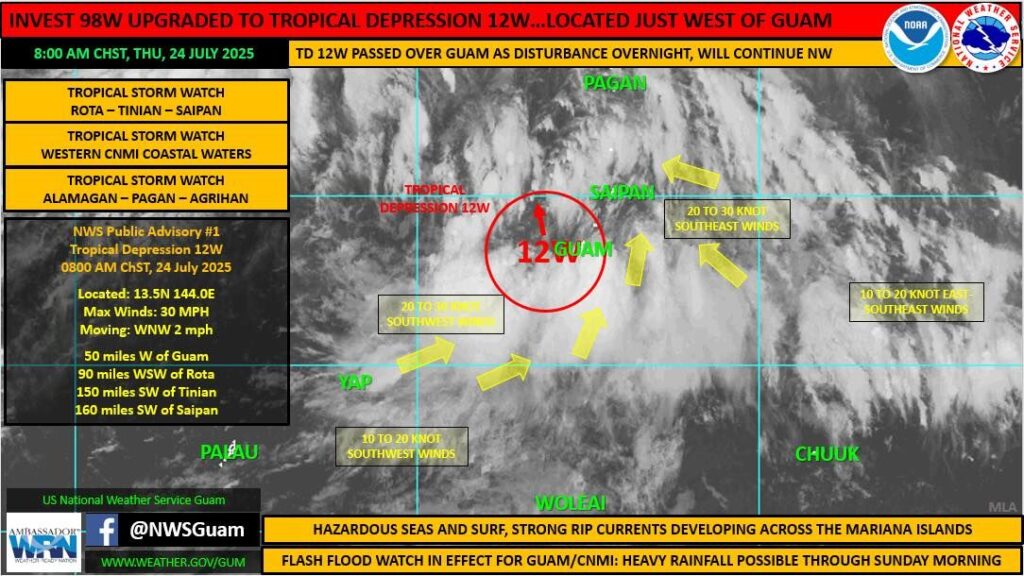
Earlier this morning, the National Weather Service – Guam issued a Tropical Storm Watch for the CNMI and surrounding waters. A tropical storm watch means that damaging tropical storm-force winds of 39 mph (sustained) are possible. A Watch is typically associated with a 48-hour timeframe for possible onset of those winds, but in this scenario, those winds are possible within 24 hours, which would correspond to a Warning. However, as those winds are currently a possibility, and not an expectation, NWS is proceeding with a Tropical Storm Watch with further analysis, and may upgrade to a Tropical Storm Warning later today, as necessary.
Tropical Depression 12W is moving west-northwest at 2 MPH. It is expected to make a turn toward the north-northwest with an increase in forward speed through Friday.
Maximum sustained winds are 30 MPH. 12W is forecast to intensify through the weekend, and it may strengthen to a tropical storm by Friday night. Residents of the CNMI are advised to continue monitoring official weather sources for the storm’s forecasted impact on other islands.
Watches and Warnings
A high surf advisory is in effect through 6 AM this Sunday. A small craft advisory remains in effect until 6 AM Sunday. A wind advisory is in effect until 6 AM Sunday. A rip current statement is in effect through late Saturday night.
A flash flood watch is now in effect through late Saturday night.
Stay Informed
The CNMI Office of Homeland Security and Emergency Management advises the community to keep a close watch on official updates relating to weather forecasts and stay informed on the latest statements and advisories which will be available through official channels (listed below) and media partners.
Again, this is an evolving situation – the direction, speed, intensification rate, and other attributes of the storm may change over the next few hours. CNMI HSEM will be monitoring the movement of the storm, continue to consult with the National Weather Service and other agencies, and continue to provide updates when available and when appropriate.
Preparedness Information for CNMI Residents:
• Expect periods of showers, thunderstorms, and locally heavy rainfall over the next several days. Winds will increase today and into the weekend as 12W passes to the West of the CNMI.
• Secure loose items such as tents, canopies, tarps, trash bins, and other items that are vulnerable to gusty winds.
• Stay informed from official sources, residents should continuously monitor the latest weather forecasts and information
from The National Weather Service (NWS) Guam.
For additional information, visit the following:
• CNMI EOC State Warning Point Facebook: https://www.facebook.com/cnmieocswp/
• NWS Website: https://www.weather.gov/gum/
• NWS Facebook: https://www.facebook.com/NWSGuam/
• Joint Typhoon Warning Center Website: https://www.metoc.navy.mil/jtwc/jtwc.html
For more information, contact CNMI HSEM Public Information Officer Bernard Villagomez at 670-287-7106 or [email protected].
###