


HAGÅTÑA (The Guam Daily Post) — Super Typhoon Mawar continues its slow approach towards Guam, and passage very near or directly over Guam is imminent, according to the National Weather Service for Guam.
“The latest forecast from the Joint Typhoon Warning Center (JTWC) indicates this storm will strengthen further to a category 5 typhoon with maximum sustained winds of 160 mph, with gusts approaching 200 mph. This is expected to occur over the next few hours, prior to making landfall,” the NWS local statement update stated just before 4 a.m.
The triple threats from Mawar include torrential rains that might result in flash flooding, catastrophic wind, and life threatening storm surge.
“This is expected for Guam, with potently catastrophic coastal flooding for southeastern and southern portions of Guam,” the update stated.
Gov. Lou Leon Guerrero ordered a mandatory evacuation of low lying, flood-prone and coastal areas Tuesday morning in light of threats from Mawar.
The supertyphoon was about 95 miles southeast of Guam just before 4 a.m.
Mawar was initially characterized as a tropical storm but grew in intensity over the last couple days.
NWS Guam stated that it had reached maximum sustained winds of 150 mph by 5 p.m. Tuesday. Just before 6 p.m. that day, the weather service announced that Mawar was now considered a supertyphoon.
President Joe Biden has approved an emergency declaration for Guam, following a request from Gov. Lou Leon Guerrero, which authorizes the Federal Emergency Management Agency to coordinate relief efforts.
“This is expected for Guam, with potently catastrophic coastal flooding for southeastern and southern portions of Guam,” the update stated
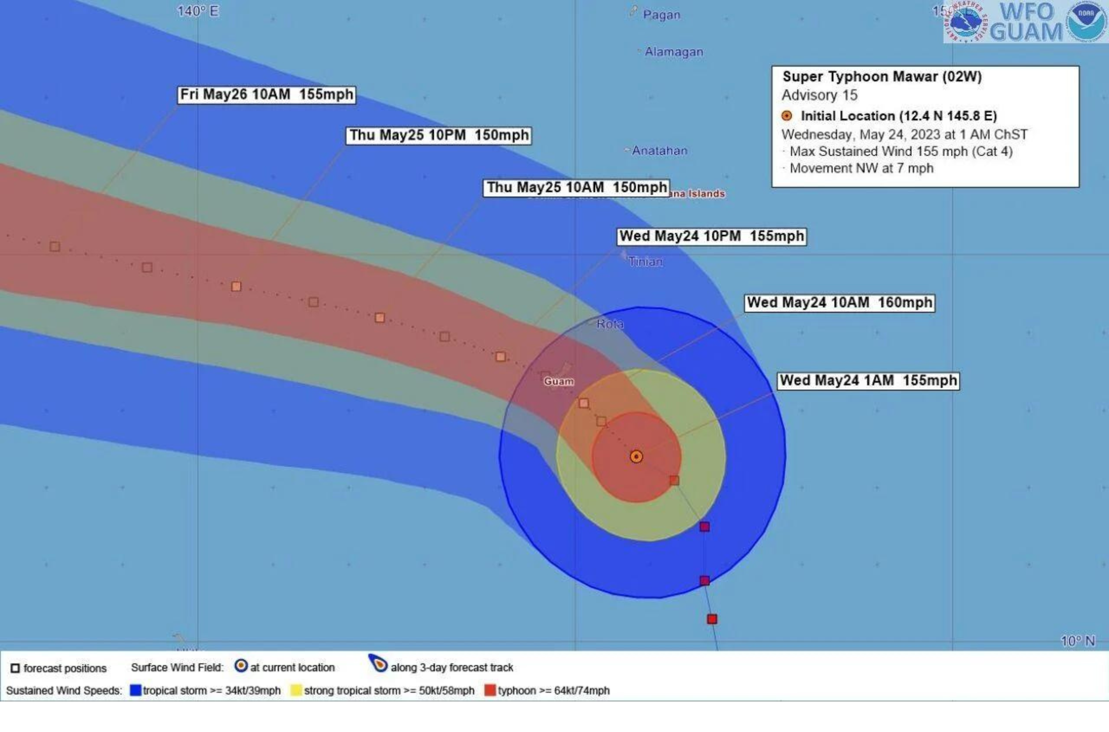
A weather graphic shows Guam is expected to receive winds of 160 mph when Super Typhoon Mawar makes its closest point of approach. The National Weather Service is forecasting Mawar to strengthen further to a Category 5 cyclone before making landfall Wednesday.