


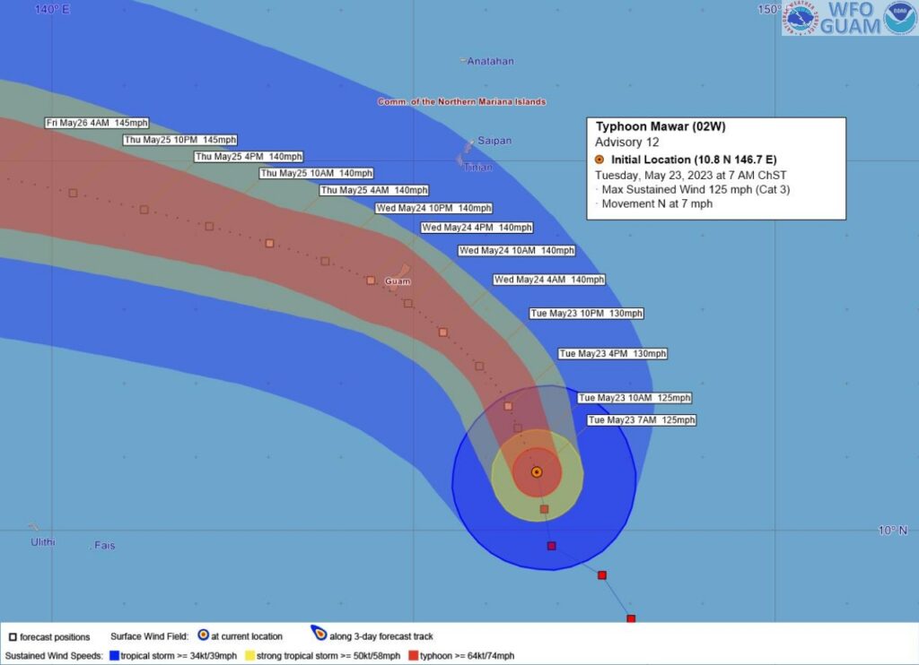
BASED on information received from the National Weather Service in Tiyan, Guam and compiled at the CNMI Emergency Operations Center-State Warning Point, intensifying category 3 Typhoon Mawar was moving north toward Guam.
Typhoon warning remains in effect for Guam and Rota. Damaging winds of 39 mph or more are expected late Tuesday evening, with the onset of typhoon force winds forecast for Wednesday morning.
Tropical storm warning remains in effect for Saipan and Tinian. Damaging winds of 39 mph or more are expected Tuesday evening into Wednesday morning.
Typhoon watch remains in effect for Saipan and Tinian. Typhoon force winds are possible if the westward turn of Mawar is delayed.
As of 7 a.m. Tuesday, Mawar was
about 225 miles southeast of Guam;
about 250 miles south-southeast of Rota;
about 300 miles south-southeast of Tinian; and
about 305 miles south-southeast of Saipan.
Mawar was moving north at 7 mph. It is expected to make a turn toward the northwest with little change in forward speed through Wednesday. The latest forecast track shows a westward bend in the vicinity of the Marianas with passage near or over Guam Wednesday.
Maximum sustained winds have increased to 125 mph. Mawar is forecast to steadily intensify through Tuesday evening possibly passing by Guam as a 140 mph category 4 typhoon.
Typhoon force winds extend outward from the center up to 25 miles. Tropical storm force winds extend outward from the center up to 100 miles.
At 8 a.m. Tuesday, Gov. Arnold I. Palacios maintained Typhoon Condition II for Rota and Tropical Storm Condition II for Saipan and Tinian.
Typhoon Condition II means that damaging winds of 39 mph or more are expected late Tuesday evening, with the onset of typhoon force winds forecast for Wednesday morning.
Tropical Storm Condition II means that damaging winds of 39 mph or more are expected Tuesday evening into Wednesday morning.