


By Walter Ulloa
For Variety
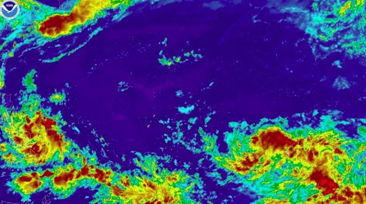
HAGÅTÑA (The Guam Daily Post) — A tropical disturbance forecasters have been monitoring in the Marshall Islands has been upgraded to a medium chance of development, the National Weather Service said Monday, marking a notable shift from just days ago when it was rated low.
Landon Aydlett, warning coordination meteorologist with the NWS Weather Forecast Office Guam, said Invest 95W is now rated medium by the Joint Typhoon Warning Center, meaning development into a tropical depression is likely, though still beyond 24 hours.
“It’s still getting its development and shape, it’s still trying to organize around a central low-level circulation center, but it’s just not there yet,” Aydlett said. “Things are trying to consolidate, trying to take shape over there in eastern Micronesia.”
The system has been slow to organize, which Aydlett said is not unusual for formative disturbances. What it does while nearly stationary in the Marshall Islands over the next day or two will be critical to determining its eventual track.
“That’s typical with all formative disturbances. They sometimes spin in place, meander in an area for a period of time, whether it’s a day or several days,” he said.
While 95W’s track remains uncertain, some models point to a passage through the Commonwealth of the Northern Mariana Islands around July 6 or 7. Others keep it east of the island chain entirely. Aydlett cautioned against reading too much into social media posts and graphics circulating online showing the storm passing over Saipan, Tinian, or even Guam.
“There’s no certainty at this point and no credibility to any single forecast scenario,” he said. “It’s just too early to say.”
Despite the uncertainty swirling around 95W, Aydlett said the week ahead and the July 4th holiday weekend are shaping up well across Guam and the Northern Marianas. Residents can expect mostly sunny skies, with only spotty, isolated showers through the week.
“We’re in good shape for the holiday weekend for the 4th of July, the nation’s 250th birthday celebration,” he said. “Sea and surf conditions will be fair and favorable.”
Combined ocean swells are expected to run three to five feet over open waters, with only a moderate rip current risk of around five feet along east-facing reefs and beaches.
Any potential influence from 95W on Guam or the Marianas would not be felt until around July 5 or 6 at the earliest, and only if the system tracks close enough to affect the region, he added.
Meanwhile, a second disturbance, Invest 96W, located northwest of Palau, is heading toward the Philippines and poses no threat to Guam, the CNMI, or Palau. The Joint Typhoon Warning Center rates it as having a low chance of development, meaning it is not expected to reach tropical depression strength.
Separately, 95W already made its presence felt over the weekend. Aydlett said satellite-derived data showed 30-knot winds along the southern and southeastern edges of the circulation, and those winds moved onshore over Majuro in the Marshall Islands, causing damage including at least one church that lost its roof, along with coastal inundation and water pushing past seawalls on the lagoon side.
As for where Guam stands in the weather calendar, Aydlett said the island is now in the wet season, though conditions will grow noticeably wetter over the next month or so.
For now, his message is straightforward: plan to enjoy the holiday weekend, but keep an eye on the forecast in the days that follow.
“Maintain awareness, keep up to date with weather forecast conditions and discussions from the National Weather Service in the coming days,” Aydlett said, “and just maintain that general state of preparedness.”
Updates are available at weather.gov/gum and through Guam Homeland Security/Office of Civil Defense.