


LOCAL architect Herman B. Cabrera recently visited Managaha Island with friends to enjoy what they once considered one of the most beautiful places in the CNMI.
However, upon arrival, they were saddened by the island’s deteriorating condition, raising concerns about the urgent need to address threats to its biodiversity and the livelihoods of those who depend on its resources.
In an interview on Saturday, Cabrera said he and his friends went on a day tour of Managaha. As they walked around, they discovered that many areas had been “neglected for so many years.”
“What I saw at Managaha was very different from what I saw a decade ago. The worst problem is the eroding sand along the east beach. Along with the erosion, tall coconut trees, pine trees, and other vegetation have fallen to the ground and into the water along the beach. The damaged area stretches less than a quarter-mile alongside the shore. I had to shorten my walk westward after realizing the debris blocked my path,” he said.
He noted that government agencies are supposed to be responsible for controlling, managing, and preventing such damage. He wondered what use these regulatory bodies are if they cannot address coastal erosion.
“Are they forgetting that their responsibility is to manage and save the beach?” he asked.
He said the responsible agencies should have already assessed the situation, made plans, and allocated a budget to address this problem so it would not continue to worsen at Managaha and other CNMI locations.
Managaha, he added, is where locals and tourists alike can relax and enjoy clean water and beautiful sandy beaches. It is priceless, he said.
He also observed that the east side of Managaha has been severely eroded by wave action, which will continue to pound the sand and wash it away from the shoreline.
“I closely observed how the waves pound the sand inland and erode the beach. It is not sea currents or other phenomena causing this erosion — it is the direct pounding of waves pushing the granular sand straight inland, not at an angle,” Cabrera said.
He estimates the beach has eroded about 16 feet inland. He wants to know if government regulations are restricting the placement of barriers that could help rehabilitate the beach.
“Is federal law preventing us from rehabilitating the beach, or is it just that [Coastal Resources Management] is not doing their job and ignoring the erosion? Managaha Island will eventually be half gone if we don’t care. This island is God-given, created for us to enjoy. Its natural setting is unique and beautiful,” Cabrera reiterated.
“If we continue to ignore the erosion, it will cost more to rehabilitate the beach if we wait too long, especially Managaha’s beach,” he added.
Ideas for saving the beach
Cabrera shared ideas on how to save the beach. One option is placing natural rock borders or concrete groin structures along the affected areas. He recalled that the CNMI government has implemented similar systems on Saipan to prevent shoreline erosion — such as at Garapan Fishing Base and Smiling Cove Marina.
He also noted that Micro Beach is showing similar erosion problems as Managaha. He wonders if any assessment or plan has been made to save Micro Beach. The visible evidence of erosion at Micro Beach, he said, mirrors the problem at Managaha.
In an interview last month, acting Department of Public Lands Secretary Sixto Igisomar said that managing Managaha requires balancing economic activities and natural resource conservation. He said the department was forming an evaluation committee after receiving proposals for exclusive tourism management concessions on Managaha.
Igisomar added that, except for the newly renovated pier, he does not support building more infrastructure on Managaha.
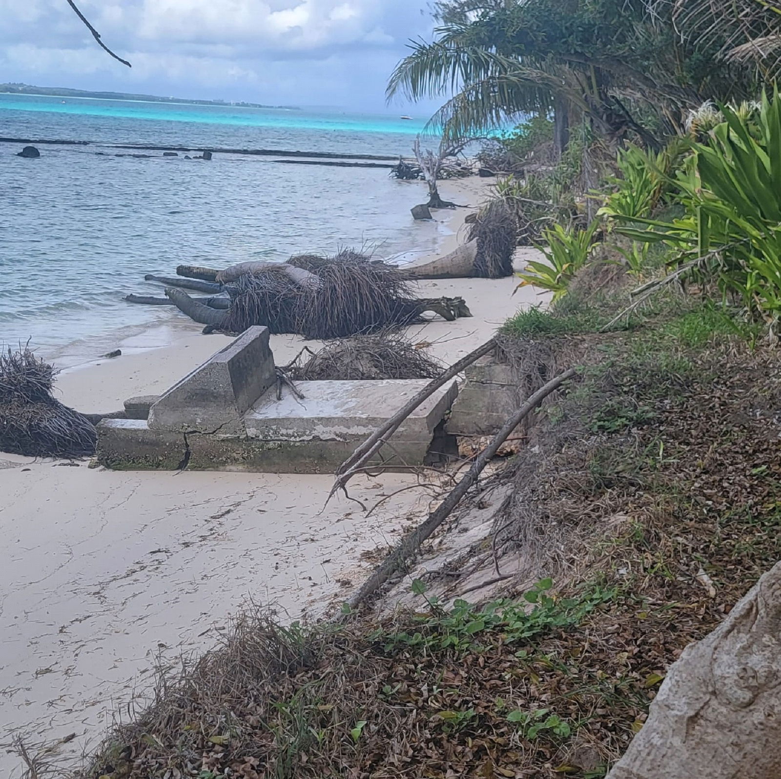
The beach at the east side of Managaha.
Contributed photo