


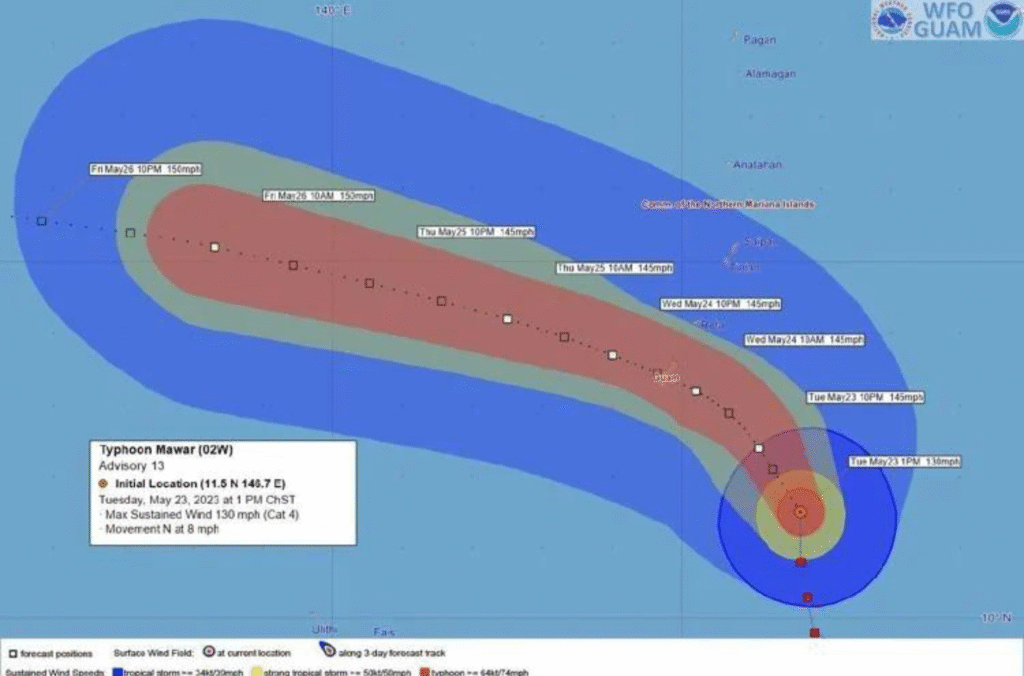
HAGÅTÑA (The Guam Daily Post) — Typhoon Mawar has now intensified to a Category 4 cyclone, which means its sustained winds are between 130 and 156 mph.
According to the National Weather Service, “catastrophic damage will occur” during a Category 4 typhoon.
At 1 p.m. Tuesday, the eye of Typhoon Mawar was about 190 miles southeast of Guam, with sustained winds of 130 mph. Its path to the island was not linear, the local office of NWS stated.
“Storm motion was wobbling towards the north to northwest at roughly 8 mph,” reported a statement released at 3:32 p.m. that was labeled “urgent.”
The odds the typhoon will pass “very near or directly over Guam” Wednesday, according to forecasters, is “increasingly likely.”
NWS is advising residents to comply with evacuation orders issued by Gov. Lou Leon Guerrero, who urged southern families in flood-prone villages to seek shelter elsewhere.
“If your home is vulnerable to high winds, or you live in a surge zone or any location prone to flooding, evacuate to a designated shelter or ride out the storm in the sturdy, fully reinforced concrete home of family or friends outside of evacuation zones,” the weather service stated.
The next local statement from NWS will be issued at 9 p.m. or sooner if conditions warrant.

A weather graphic shows the forecast track of Typhoon Mawar, now a Category 4 cyclone, as it approaches Guam.