


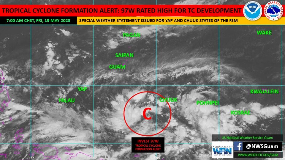
The US National Weather Service in Guam has issued a tropical cyclone formation alert, upgrading Invest Area 97W to a rating of HIGH. This indicates that there is a high probability of tropical cyclone development within the next 24 hours. Currently located approximately 200 miles south-southeast of Satawal and 610 miles south-southeast of Guam near 5N149E, the main focus in the short term is Chuuk and eastern Yap State, followed by the Marianas.
For residents of Chuuk and eastern Yap State, it is important to closely monitor communications and forecasts regarding 97W. The Special Weather Statement for Yap and Chuuk States remains in effect, providing detailed information on wind, weather, seas and surf, as well as the threat of flash flooding and mudslides. The statement can be found on the NWS website.
In the Marianas, 97W is expected to favor a track towards the area early next week. As the tropical cyclone is still in the early stages of development, there is a lot of uncertainty in terms of its potential track and strength. Forecasts have indicated a higher chance of rain and increasing winds between Monday to Wednesday. Residents in the Marianas are advised to pay close attention to subsequent weather forecasts and discussions from the NWS as the situation evolves.
<div dir=”auto”>19 May 2023 – 7:30 am ChST</div>
<div dir=”auto”> </div>
<div dir=”auto”><strong>TROPICAL CYCLONE FORMATION ALERT</strong></div>
<div dir=”auto”> </div>
<div class=”x11i5rnm xat24cr x1mh8g0r x1vvkbs xtlvy1s x126k92a”><div dir=”auto”>The JTWC has upgraded 97W to a TCFA meaning that development into a significant tropical cyclone (tropical depression or greater) is likely within the next 24 hours.</div><div dir=”auto”> </div></div>
<div class=”x11i5rnm xat24cr x1mh8g0r x1vvkbs xtlvy1s x126k92a”><div dir=”auto”>Prognosis remains unchanged for the FSM with heavy weather expected the next few days.</div></div>
<strong>What to do Before, During, and After a Typhoon</strong>
<strong>Before a Typhoon:</strong>
<ul><li>Have a disaster plan</li><li>Board up windows</li><li>Know where all the evacuation routes are</li><li>Prepare a disaster supply kit for your home and car</li><li>Have enough food and water for at least three days, including a first aid kit</li><li>Have some cash handy – banks and ATMs may be temporarily closed</li><li>Make sure your car is filled with gasoline</li></ul>
<strong>During a Typhoon:</strong>
<ul><li>Stay away from low-lying and flood-prone areas</li><li>Leave mobile homes and go to a shelter</li><li>If your home isn’t on higher ground, go to a shelter</li></ul>
<strong>After a Typhoon:</strong>
<ul><li>Check for injured or trapped people without putting yourself in danger</li><li>Watch out for flooding, which can happen after a typhoon</li><li>Do not attempt to drive in flooding water</li><li>Stay away from standing water – it may be electrically charged from underground or downed power lines</li><li>Don’t drink tap water until officials say it’s safe to do so</li></ul>
<strong>Tropical Disturbance Expected to Impact Marianas; Take Action to Prepare</strong>
Based on the current forecast, the disturbance identified as 97W is likely to track towards the Marianas, potentially passing very near or over certain parts of Guam or the CNMI early next week. The weather conditions in the Marianas are expected to remain clear throughout the weekend, but inclement weather, including heavy rainfall, is anticipated to commence as early as Monday and persist until Wednesday.
-Offices of Homeland Security and Civil Defense in Guam May 19. 2023 10:05 AM
<div class=”tnt-ads-container text-center”> </div>
