


By Walter Ulloa
For Variety
HAGÅTÑA (The Guam Daily Post) — The tropical disturbance forecasters had their eyes on earlier this week appears to be running out of steam, but that is not the end of the story.
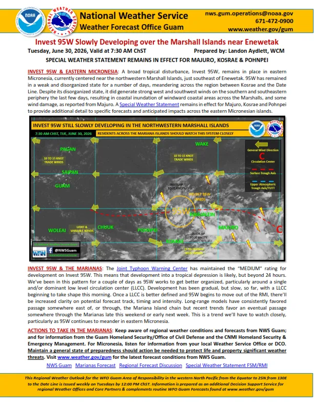
Landon Aydlett, warning coordination meteorologist at the National Weather Service Weather Forecast Office Guam, said Wednesday that Invest 91W, the weak circulation being tracked in eastern Micronesia, shows little promise of developing into anything significant.
“It’s very difficult to find even a defined low-level circulation center, but more of an open wave trough near Pohnpei State,” Aydlett told The Guam Daily Post. “It’s very possible this disturbance could fizzle out, and eventually (the Joint Typhoon Warning Center) would close that invest area. It’s still very early, very disorganized.”
What has Aydlett’s attention now is not 91W itself, but what could potentially follow it.
Some forecast models are already pointing to another disturbance forming farther east, possibly emerging out of the Federated States of Micronesia and eventually heading toward the Marianas sometime around the middle to end of next week. Aydlett was careful to put heavy caveats on that picture.
“The timing varies significantly, the intensities vary significantly, and the range of passage varies significantly from anywhere through Yap State to staying well to our east moving into the North Pacific,” he said. “So there’s really not much to work on.”
He added that with it being Wednesday, any scenario playing out the following Wednesday or later is, by weather forecasting standards, a long way off.
“Don’t focus on one single forecast model and say this is going to happen because it’s simply too early,” Aydlett said.
According to Aydlett, if a storm does eventually develop and earn a name, the next one on the typhoon committee list is Hagupit, a Filipino word meaning “to lash,” “whip,” “thrash,” or flog.
“I hope we don’t have a Hagupit move through our region,” he said.
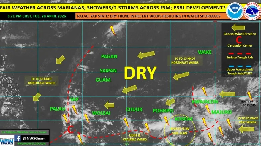
For now, though, Guam and the rest of the Mariana Islands are in for a stretch of calm weather. A trade wind surge is pushing breezy conditions through the region Wednesday and into Thursday night, with winds running around 15 to 20 miles per hour. After that, conditions ease heading into the weekend.
The NWS has issued a high risk of rip currents for east-facing reefs and beaches through Thursday due to elevated trade wind swell, and Aydlett noted there is a slim chance of a passing shower over the next day or so as some lightning activity to the east drifts through.
“You can’t rule out a rumble of thunder or maybe a couple (of) flashes of lightning, but otherwise some spotty showers over the next 24 to 36 hours, and then this is going to be a drier weekend ahead,” he said.
No watches, warnings, or advisories are currently in effect for Guam or the Commonwealth of the Northern Mariana Islands.
Guam remains technically still in the dry season, though Aydlett noted that rainfall for the year so far is running above normal. The transition toward the wet season typically begins around May and June.
His advice to residents is familiar and straightforward: do not lock in on any one forecast model, stay tuned to official channels, and use the current window of good weather to quietly prepare.
“Enjoy the fair weather,” Aydlett said. “Take whatever actions you need to do to pick up the pieces remaining from Sinlaku, but also maintain a general state of preparedness, as we should all the time in our region, and keep a side eye to nature, because once something does start to take shape, if it does, we’ll need to be ready to rock and roll with it.”
The NWS Guam forecast office plans a fresh update by Friday, when a clearer picture of conditions in eastern Micronesia may begin to take shape. For the latest information, visit weather.gov/gum or the NWS Guam Facebook page. The office is also reachable around the clock at 671-472-0900.