


By Walter Ulloa
For Variety
HAGÅTÑA (The Guam Daily Post) — A storm alert issued Tuesday afternoon confirmed what forecasters had been watching for days: tropical disturbance 93W, already drawing concern, is now on a tighter timetable to become something more organized and potentially dangerous.
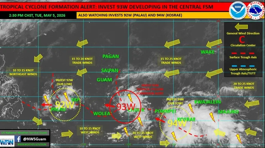
The Joint Typhoon Warning Center upgraded 93W to a tropical cyclone formation alert, meaning forecasters believe it could develop into a tropical depression within 24 hours, said Landon Aydlett, warning coordination meteorologist at the National Weather Service Weather Forecast Office Guam.
The alert puts the system’s center just west of Weno in Chuuk, and while the track is expected to carry it well south of Guam, the island and the rest of the Marianas will still feel the effects.
“We do not expect this to pass over or through the Mariana Islands, but there are some showers on the northern periphery that will be moving in over Guam and the southern Mariana Islands starting tonight and through Wednesday (and) Wednesday night,” Aydlett told The Guam Daily Post.
As of Tuesday, NWS was tracking three disturbances in the region: 92W near Palau, 93W near Chuuk, and a newly designated 94W near Kosrae. Aydlett noted the development of 94W is consistent with what he had been signaling days earlier.
“This is just that ongoing, very busy pattern that I was alluding to early last week, with multiple disturbances coming through,” he said.
For Guam, the near-term picture calls for increasing showers overnight into Wednesday as 93W passes to the south through Micronesia. Trade winds, already running at 15 to 20 mph, are expected to surge to 20 to 25 mph sustained through Wednesday. Combined seas are forecast at 6 to 9 feet, and NWS has issued a high rip current risk statement for east-facing reefs and beaches from Wednesday night into early Thursday.
The wetter pattern is not entirely unwelcome. Vegetation knocked down by Super Typhoon Sinlaku has been drying for several days, raising fire concerns across the region. Any rainfall will help ease that danger.
“Every bit of rainfall will help us as far as any kind of short-term fire danger,” Aydlett said. “They especially need the rainfall up there in Saipan.”
He said Guam is likely to see more rain from this system than Saipan and Tinian.
93W itself could reach tropical storm strength by the time it nears Yap later this week. Aydlett said NWS will watch closely for impacts to Yap State’s outer islands as the system tracks westward toward the Philippines.
Forecast models are struggling to resolve 94W, partly because it is tracking close to 93W and the two are competing for the same limited energy.
“If they can start getting some space and some separation, then we could see 93 and 94 both start to show some organization apart from each other,” Aydlett said. “But 94W, we’re going to have to watch that one closely.”
He added the system is already generating showers, thunderstorms, and gusty winds across Pohnpei and Kosrae states. Any potential impact to Guam from 94W would be more of a next-week concern.
As of Tuesday, the only active advisory for Guam was the high rip current risk statement.
For the latest forecasts, visit weather.gov/gum or call 671-472-0900.