


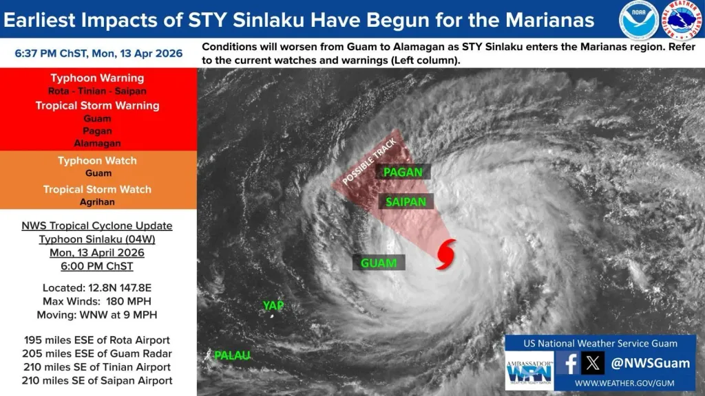

Monday, April 13, 2026.
Valid at 6:37 PM ChST
Super Typhoon Sinlaku (04W)
6:00 PM ChST Tropical Cyclone Update
Typhoon Warning: Rota, Tinian, Saipan
Tropical Storm Warning: Guam, Pagan, Alamagan
Typhoon Watch: Guam
Tropical Storm Watch: Agrihan
(NWS) — The outer rainbands and wind-field of Super Typhoon Sinlaku (04W) have arrived at the Marianas, so weather conditions will continue to worsen through tonight.
According to observation sites, gusts of 54 MPH and 61 MPH were reported at Guam and Saipan, respectively, in the last hour. The maximum sustained winds near the center are 180 miles per hour, meaning STY Sinlaku remains at a Category 5, and is moving west-northwest at 9 miles per hour.
The onset of tropical storm-force winds is expected to reach Guam, Rota, Tinian, and Saipan now, if not, tonight. Typhoon-force winds are expected to start reaching Rota, Tinian, and Saipan Tuesday or Tuesday afternoon. Heavy rainfall with locally higher showers and isolated thunderstorms poses flash flooding and lightning threats to the entire region. Seas and surf are building to dangerous levels, with maximum wave heights of 21.52 feet at Ipan Buoy and 13.58 at Tanapag Buoy as of this issuance. Significant coastal inundation is expected for the entire region.
The latest Joint Typhoon Warning Center forecast states STY Sinlaku will slightly weaken, but Category 4 or 5 at landfall is still possible. The forecast track remains over Tinian and Saipan with more favorable shifts towards the north. However, Guam, Rota, Pagan, Alamagan, and Agrihan are still within the wide wind field and heavy rain bands.
The Northern Marianas will experience worsening conditions from STY Sinlaku as well, hence the continuation of watches and warnings for Pagan, Alamagan, and Agrihan.
Closely monitor NOAA weather radio or local news outlets for official storm information. Listen to local government officials regarding evacuations, storm preparations, and shelter designations.