


By Walter Ulloa
For Variety
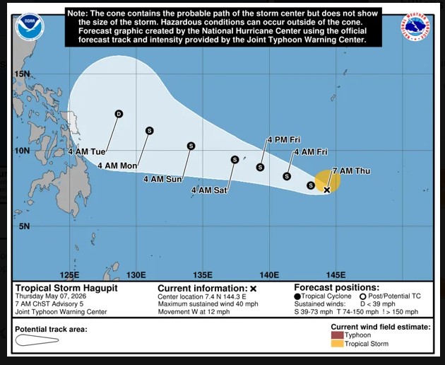
HAGÅTÑA (The Guam Daily Post) — Tropical Storm Hagupit is churning slowly through Yap State and poses no direct threat to Guam or the Commonwealth of the Northern Mariana Islands, the National Weather Service confirmed Thursday.
“Hagupit will not be coming anywhere close to Guam or the Mariana Islands, and it will track just northeast of Palau,” Landon Aydlett, warning coordination meteorologist at the NWS Weather Forecast Office Guam, told The Guam Daily Post.
As of 10 a.m. Thursday, Hagupit was located about 20 miles southeast of Woleai in central Yap State, roughly 440 miles east-southeast of Yap proper. The storm was moving west at 12 mph with maximum sustained winds of 40 mph.
Forecasters expect Hagupit to gradually turn west-northwest and slow down over the next day or two as it continues strengthening. The NWS said the storm could become a strong tropical storm with sustained winds exceeding 58 mph by the time it nears Yap proper, which it is forecast to pass very close to or just south of late Friday night or early Saturday morning.
Tropical storm warnings are in effect for Faraulep, Woleai, Ulithi, and Fais, where tropical storm conditions are occurring or expected within 24 hours. A tropical storm watch covers Yap and Ngulu, where such conditions are possible within 48 hours.
The NWS urged residents across eastern Yap State to remain in safe shelter and avoid inter-island travel until the storm passes. Residents on Ulithi, Fais, Yap proper, and Ngulu were advised to complete storm preparations as quickly as possible before conditions deteriorate.
Aydlett said Hagupit is a short-lived system and should gradually weaken after clearing Yap State. He noted, however, that residents in Samar and areas northward into northern Luzon in the Philippines should keep a close eye on the storm, as it could still bring heavy showers to those areas even if it remains offshore.
The Joint Typhoon Warning Center also formally closed Invest 94W, the tropical disturbance near Kosrae that forecasters had been monitoring. With that system no longer a concern, Aydlett said the outlook for Guam and the CNMI looks relatively settled.
“There are no anticipations, no expected problems from that area,” he said. “But while it’s there, we will watch it, and if there’s something to emerge from there in the coming days or the next week, we’ll make it known to everybody.”
Although Hagupit is not headed toward Guam, residents will still feel the storm’s influence. A high surf advisory runs through Thursday afternoon, with a high rip current risk continuing through the weekend along north- and east-facing reefs and beaches. Waves of eight to 12 feet are expected along east-facing reefs. A small craft advisory for seas of eight to 11 feet was set to expire at 5 p.m. Thursday.
The elevated surf and seas are tied to surging trade winds that have been building across the region for several days. Aydlett said those winds will gradually ease but remain breezy through the weekend, with mostly fair weather ahead.
As for rainfall, residents hoping for relief from the recent dry stretch should not count on much. Aydlett said any showers will be fleeting and on the move.
“They’re going to be brief in nature, short duration, and quickly moving,” he said. “It’s not going to be a soaking rainfall that they really need for the drying conditions. It’s just going to be more of a brief passing shower.”
Guam remains in the dry season, with the transition to the wet season still one to two months away. Even so, Aydlett said the calendar offers no assurances when it comes to tropical weather.
“Tropical cyclones are, despite the season, a possibility any time throughout the year,” he said.
For the latest forecasts and conditions, visit weather.gov/gum or follow NWS Guam on Facebook.