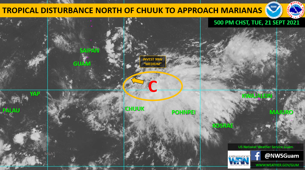


(Press Release) — Weather-Ready Nation on Tuesday said it was monitoring a tropical disturbance north of Chuuk in the Federated States of Micronesia.
“It is designated as Invest Area 99W by the Joint Typhoon Warning Center and rated as ‘Medium’ for development. A ‘Medium’ means that development into a tropical cyclone (tropical depression) is likely, but expected to occur beyond 24 hours.”
Earlier Tuesday afternoon, 99W was centered near 10.3N154.7E, moving generally west-northwest to northwest.
99W is generating a large area of showers and thunderstorms across the FSM Tuesday afternoon and evening, along and south of an elongated surface trough extending from the southwest of 99W to the northeast.
This system, in some form, will approach the Marianas on Thursday. As is typically the case in these developing disturbances, uncertainty remains high as to how 99W will evolve in the coming days.
Numerical forecast model solutions vary, ranging from a weak, broad circulation passing south of Guam to a smaller stronger circulation passing through the Marianas.
Residents of Guam and the CNMI should keep a close watch on regional weather conditions by keeping up-to-date on the latest weather forecasts and conditions from NWS Guam.
A surface trough was expected to bring scattered showers and isolated thunderstorms to the Marianas Tuesday through Wednesday morning, then 99W will bring more showers, thunderstorms and the potential for gusty winds Thursday and Friday.
For more information go to
NWS Guam: https://www.weather.gov/gum/
NWS Guam Public Forecasts: https://www.weather.gov/gum/PublicForecasts
NWS Guam Tropical Cyclones Page: https://www.weather.gov/gum/Cyclones
NWS Guam Facebook: https://www.facebook.com/NWSGuam and Twitter: https://www.twitter.com/NWSGuam
Guam Homeland Security/Office of Civil Defense: www.ghs.guam.gov and www.facebook.com/GHSOCD
CNMI Homeland Security and Emergency Mgmt: www.cnmihsem.gov.mp and www.facebook.com/cnmieocswp