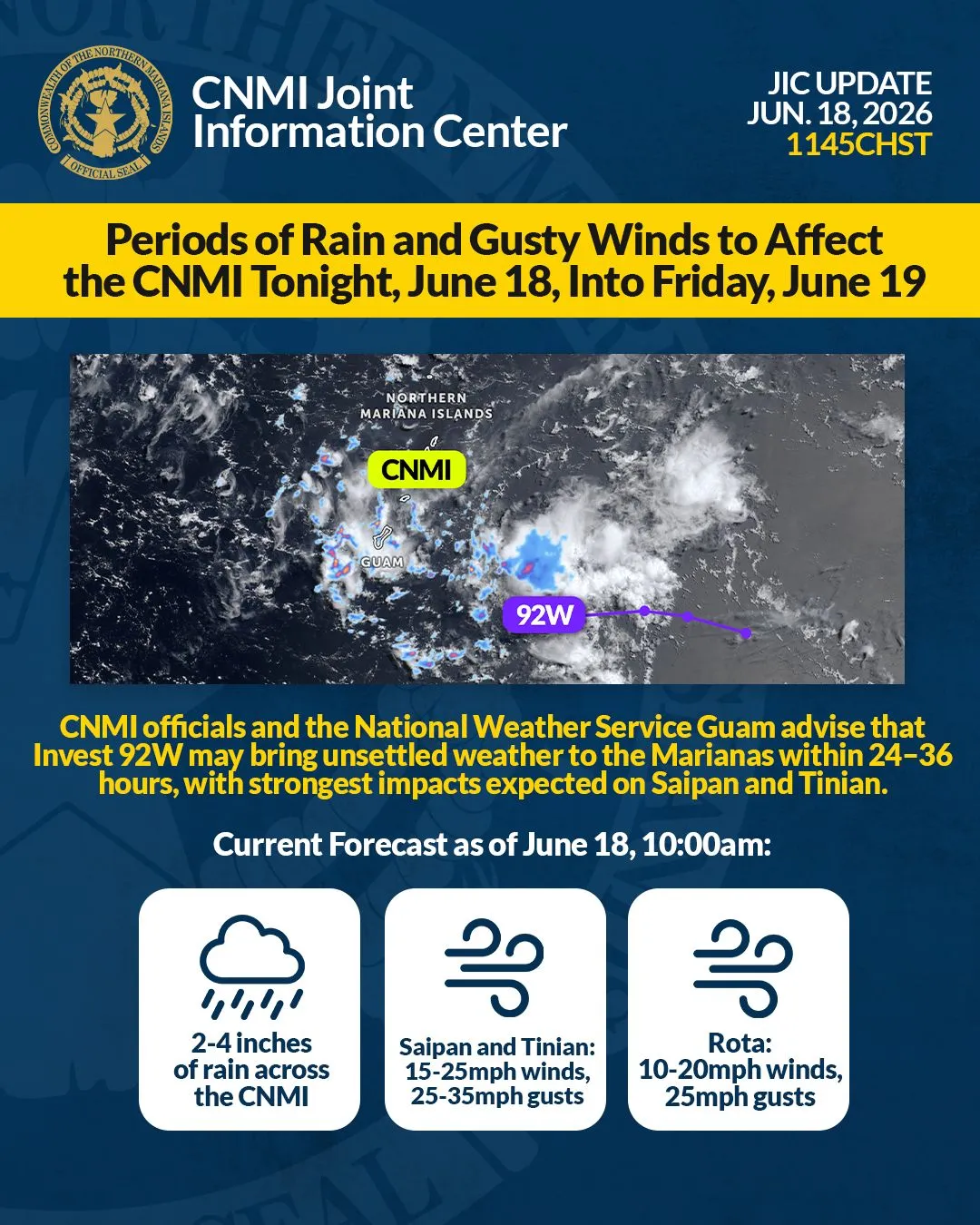


According to Humanities Council executive director Scott Russsell, “What this would entail is a series of maps — self-guided maps — with information about the sites and how you to get to them.”
For Russell, it is up to the tourists or the CNMI residents to either complete the entire trail or choose to explore a part of it on foot.
He told Variety that they are currently working on the project and they expect to have it completed before Dec. 31, 2012.
In the meantime, Russell said the Humanities Council needs to get together with the stakeholders. “We have a series of sites that we have tentatively identified.”
He said they would try to cover a full range of sites.
With $10,000 funding under the “We the People” program of the National Endowment for the Humanities, the Garapan Trail project will involve a series of maps in different languages.
Russell confirmed to Variety, “We’ll produce these maps in a series of languages that will be usable for our visitors. We are looking at Japanese, Korean, Chinese, Russian, and probably English.”
For Russell, translating the map into various languages is the biggest work in the project.
“We hope to find good translators,” said Russell adding that they would appreciate if they could find a good translator who could help them work on the project at no cost.
The Garapan Trail project would give an authentic sense of place he said.
He shared with Variety the cultural significance of the Garapan area.
Russell said, “Garapan is an important location for Carolinian settlement in the 19th century.”
He also said there are important Spanish and German sites that have long been obscured by modern development.
“You don’t really realize how rich Garapan area is. There are still a number of remnants of those periods,” he said.
He added, “There is a lot of history and culture in that area that people don’t know about.”
He cited as example the area that the Duty Free Shoppers Galleria now occupies.
Russell said Garapan is an interesting spot because there were ancient Chamorro villages in the area.
The area where the latte stone stands at the DFS used to be an ancient burial ground, he said.
“It must have been one big latte village at one time,” he said.
He also said that across from this site was formerly known as the first mission village first established in the 1690s.
“We found the remnants of what looks to be the mission cemetery where people were buried with iron implements,” he said.
Garapan is also where the ancient Carolinian settlements used to be located — “where the Carolinians came ashore and set up the villages.”
Russell also said Micro Beach has cultural significance to Carolinians.
These and so much more make Garapan an interesting place to rediscover.
Russell said the self-guided map is a way to educate visitors and even local residents about what makes this place unique.
Once the maps have been printed, Russell said they are planning to have these distributed in the hotels.
They are also looking at providing copies to the public.
In the meantime, they have a rough listing of historical/cultural sites.
Russell said they are also working closely with the Historic Preservation Office that took on the project of providing signage to the sites.