


By Walter Ulloa
For Variety
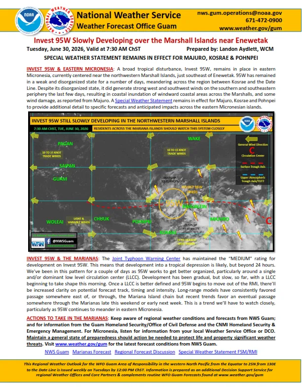
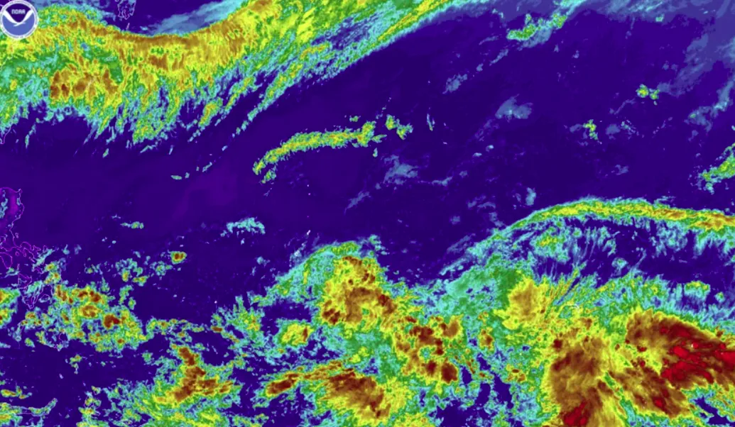
HAGÅTÑA (The Guam Daily Post) — A pair of tropical disturbances stirring across Micronesia has the National Weather Service keeping a close eye on the region as Guam and the Northern Marianas head into the Memorial Day holiday weekend.
Landon Aydlett, warning coordination meteorologist with the NWS Weather Forecast Office Guam, said forecasters are watching two designated areas of interest, 99W, just west of Chuuk, and 90W, south of Kwajalein and Kosrae. Both are being tracked in coordination with the Joint Typhoon Warning Center.
“We are watching these two specific areas for potential development,” Aydlett told The Guam Daily Post Friday morning. “Not yet guaranteed, but it’s potential development as we go later into the weekend.”
For now, both systems are rated sub-low by the JTWC, meaning significant development is not expected in the coming days. That could change.
“Depending on how things progress, they could be upgraded to low and then to medium, and we’re probably a good 24 to 48 hours away from that happening,” Aydlett said. “That’s assuming development occurs.”
Forecast models have been signaling the possible development of one or two tropical cyclones within the western North Pacific, most likely in the Philippine Sea, though Aydlett noted that timeline has been shifting.
For Guam and the Northern Marianas, the immediate picture remains manageable. Fair weather holds through Friday night, with shower coverage climbing to around 30 percent Saturday and Saturday night, then reaching 50 percent Sunday through Monday and into next week. The long-range outlook depends heavily on where the disturbances track once they move out of Micronesia.
“Most trends favor the action passing by to our south,” he said. “But we’ll have to watch that, especially as we get into Monday and Tuesday.”
For the Northern Marianas, conditions should stay a bit drier, with trade winds keeping the northern islands on the drier edge of the system’s reach. Guam, sitting on the northern periphery of the disturbances, will likely see more clouds and showers mixed in with sunshine.
“Make sure you come ready with an umbrella, but also your sunglasses,” Aydlett said.
On surf and sea conditions, combined seas are running 5 to 7 feet, down slightly from earlier in the week. Surf along east and north-facing reefs and beaches will range from 6 to 8 feet. No coastal advisories are in effect, though rip currents remain a factor.
“The rip currents will still be there, but not as strong as what they’ve been the last couple of days,” Aydlett said.
His message heading into the three-day weekend is measured, stay informed, keep weather in your plans, but do not panic.
“Is this a time to worry and be anxious about things? No, not yet,” he said. “We’re going to be watching and assessing things into the weekend, but keep weather in the forefront of your plans for showers and thunderstorm potential, and then we’ll watch things closely next week.”
Looming beyond the holiday weekend is a bigger, longer concern. Forecasters are tracking the transition from El Niño-Southern Oscillation, or ENSO, neutral conditions to what could become a significant El Niño year, one that some indicators suggest could rival or surpass the powerful 1997 event.
“A lot of the indicators still are favoring and pointing to a strong El Niño similar to the 1997 year, maybe even stronger,” Aydlett said.
That carries consequences well beyond this typhoon season. A strong El Niño typically brings a more active year for tropical cyclone development closer to the Marianas, followed by a sharper, longer dry season. Aydlett said the dry season of early 2027 is already a concern on the horizon, with the potential for drought conditions and elevated wildfire risk.
“The dry season tends to be much drier and longer than normal,” he said. “So that’s going to be the concern once we get past the holidays later this year.”
A fuller picture is coming. NWS Guam will hold a press conference June 4 at 10 a.m. at the Homeland Security office, where Aydlett and colleagues will present the 2026 Western North Pacific Tropical Cyclone Season Outlook, updated El Niño information, and a recap of Super Typhoon Sinlaku.
In the meantime, Aydlett’s advice is simple: watch the forecast, enjoy the weekend where the weather allows, and stay ready.
“Weather here can change fast, so keep an eye on the forecast, stay flexible with your plans, and we’ll keep everyone updated as these systems move across the region,” he said.
For the latest, visit weather.gov/gum or the NWS Guam Facebook page.