


By Walter Ulloa
For Variety
HAGÅTÑA (The Guam Daily Post) — The depression, which began as Invest 92W, produced Guam’s roughest night in months, sending wind gusts up to 55 mph before dawn Friday and underscoring that even a relatively modest storm can pack a punch when it passes close enough.
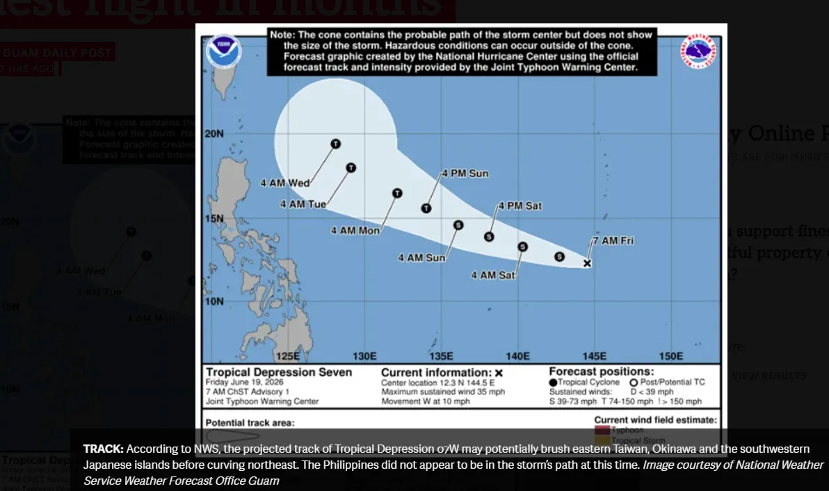
The Joint Typhoon Warning Center upgraded the disorganized cluster of clouds and rain to Tropical Depression 07W at 7 a.m. ChST Friday; by then the system was about 85 miles south-southwest of Guam, moving west at 10 mph with maximum sustained winds of 35 mph.
Landon Aydlett, warning coordination meteorologist at the National Weather Service Weather Forecast Office Guam, said the overnight intensification drew attention even though the broader outcome matched what forecasters had anticipated.
“We were also looking at the stronger winds on the north side of the system,” Aydlett told The Guam Daily Post Friday morning. “We were anticipating a passage very close to Guam, or just over the southern waters, and of course, if there is a shift to the south, then those stronger winds that are up on the north side would funnel in over Guam, and that’s exactly what happened overnight.”
Antonio B. Won Pat International Airport recorded the island’s peak gust at 55 mph around 3 a.m., and Andersen Air Force Base logged a gust of 48 mph just before midnight. Both gusts came with heavier showers that pushed through beginning around 11 p.m. Thursday. Sustained winds generally held between 20 and 25 mph through the night.
Guam Homeland Security and the Office of Civil Defense issued a public advisory Friday morning. A Wind Advisory and Small Craft Advisory for Guam coastal waters remained in effect until 5 p.m., with southeast winds of 15 to 25 mph and gusts up to 40 mph expected to gradually ease through the afternoon. Coastal seas of 7 to 9 feet made conditions hazardous for small vessels. Residents were urged to secure loose outdoor items, drive with extra caution and keep small craft out of the water.
Aydlett said conditions were already improving Friday morning as the depression moved further away.
“Right now, 07W is pulling away from us, so the stronger winds wrapped around the core of that depression, those are pulling further away from us to the southwest and west,” he said. “Additionally, with less rainfall across the area, we’re not going to see quite as much strong wind gusts.”
Partly cloudy skies were expected by afternoon, with sunshine possible later in the day. The weekend looked considerably better, with lighter winds and more abundant sunshine through Saturday and Sunday.
Aydlett cautioned the story was far from over for 07W. He said the depression was expected to become a tropical storm later Friday and could intensify significantly as it moved into the Philippine Sea over the coming days.
“There is potential to become a major typhoon in the Philippine Sea,” he said. “The current forecast track does indicate the possibility of a Category 3, Category 4 typhoon by early next week.”
If and when the system strengthens enough to receive a name, it will be called Mekkhala, a name contributed by Thailand to the World Meteorological Organization’s Typhoon Committee list. In Southeast Asian Buddhist mythology, Mekkhala is revered as the guardian angel of the seas.
It would be only the second major typhoon of 2026 in the western North Pacific, following Super Typhoon Sinlaku earlier this year.
Aydlett said the projected track showed 07W potentially brushing eastern Taiwan, Okinawa and the southwestern Japanese islands before curving northeast. The Philippines did not appear to be in the storm’s path at this time.
“If anyone’s got travel plans up to Taiwan or Japan, keep an eye on this closely,” Aydlett said.
Meanwhile, a second disturbance, Invest 93W, remained in eastern Micronesia. Aydlett said that system currently showed little development potential in the near term but warranted watching given the active weather pattern across the region.
“It’s a very busy, soupy pattern across eastern Micronesia, with showers and thunderstorms,” he said, noting that some forecast models suggest possible activity in the coming days, though with limited support at present.
For now, Guam got a breather. Aydlett said no additional tropical threats were on the immediate horizon for the island, and residents could look forward to a quieter stretch heading into next week.
The latest forecasts, advisories and updates are available at weather.gov/gum and through GHS/OCD