


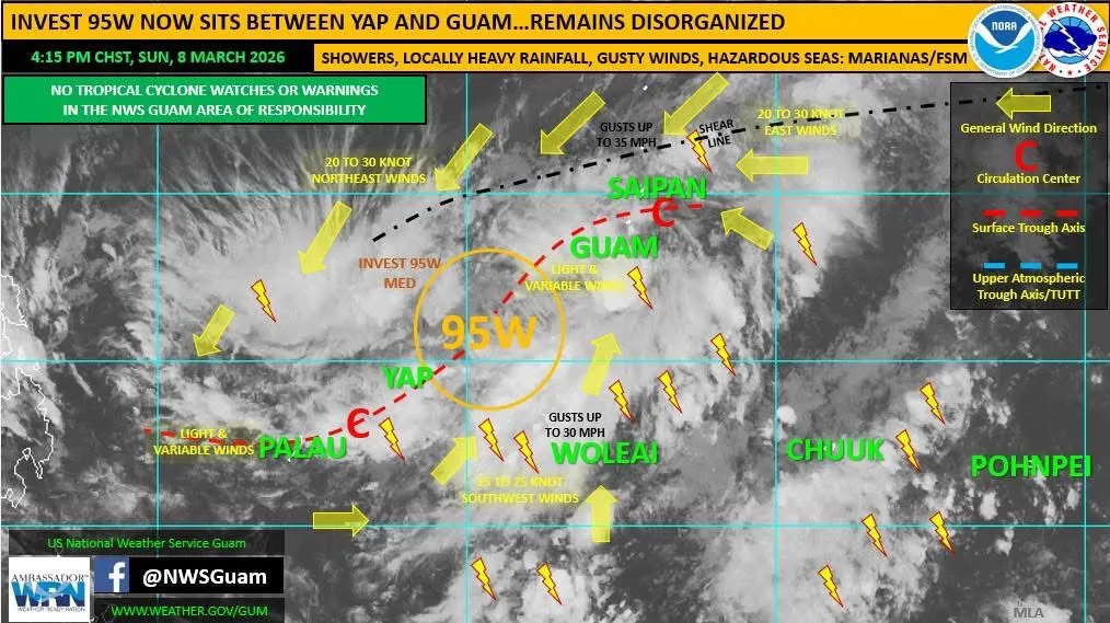
(NWS) — Invest 95W remains a disorganized tropical disturbance, now centered 175 miles northeast of Yap Proper near 11.0N 140.2E.
The Joint Typhoon Warning Center stated in their 4 p.m. bulletin on Sunday that 95W is characterized by a “highly elongated circulation” and composed of a trough that extends northeastward over the Marianas.
95W is now in a marginally favorable environment for development, but maintains a rating of “medium” for development, meaning that development into a tropical depression is still a possibility, but such organization would not take place within the next 24 hours.
Unlike Saturday, numerical models are inconsistent with additional formation of 95W, with general trends backing off development potential.
General outlook
The overall pattern across western Micronesia and the Marianas remains a complex one, with the disturbance, 95W, and its associated surface trough…and the shear line, all in our vicinity. The likelihood of any significant development of 95W continues to decrease (good news!) however, the overall forecast scenario for the region (wet!) remains unchanged.
Residents across the Marianas, Yap State and Chuuk State, and to some extent, Palau, should continue to expect periods of showers, thunderstorms, gusty winds and the potential for locally heavy rainfall. Weather associated with this disturbance spreads across a very large area of the region and is not simply confined to the actual core of the disturbance.
In the longer range, forecast models keep this surface trough and the broader area of disturbed weather in the vicinity for several days, possibly through mid to late week. We could see additional weak circulations form within the trough in the coming days, but none are favored for significant development. Regardless of specific details of the weather environment, residents across the region should expect a prevailing wet pattern to continue into the coming week.
Winds & gusts
Winds across several islands have been light and variable, sometimes calm, while breezy with gusts across other islands. Locations where the trough axis passes overhead, or nearby, will see light and variable winds (Guam, Rota, Yap, Palau), with the stronger winds farther east and southeast of the trough axis (islands of eastern Yap State, including, but not limited to, Woleai) and farther west and northwest of the trough (the Philippine Sea). Stronger winds are also found to the north near and north of the shear line (Tinian, Saipan and islands farther north).
Wind forecasts will vary based on where the trough axis sits. Lighter winds will prevail within and near that trough axis. However, heavy showers could move in with brief stronger wind gusts.
Rainfall
Rainfall forecasts remain tricky. Guam and the CNMI saw a bit of a lull in showers Saturday night and Sunday morning. However, heavy showers were around 50-100 miles offshore to the east and southeast for much of that period, with light and spotty showers over the islands. This prevented any flood-related concerns overnight and this morning. However, the potential remains for more showers now through Monday afternoon, with locally heavy rainfall still possible. Similar conditions exist across western Micronesia, particularly across Yap State. Therefore, the Flood Watch remains in effect for Guam and the CNMI.
Seas & surf
Seas and surf remain hazardous across the Marianas due to large surf up to 11 feet along north and east facing reefs and beaches (High Surf Advisory and High Risk of Rip Currents) and combined seas of 8 to 10 feet and winds of 15 to 25 knots with gusts up to 35 knots (Small Craft Advisory). Expect these hazardous conditions to prevail through Tuesday across the region.
As this general pattern continues to evolve, keep up to date with the latest regional weather forecasts and conditions from NWS Guam on the web at www.weather.gov/gum